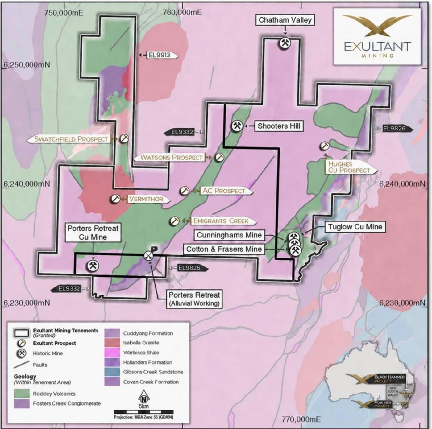
Macquarie Arc volcanics and intrusives.
The Ordovician arc rocks that host Watsons and the monzonite at Porters Retreat are the same arc that hosts New South Wales' biggest porphyry systems.
~390 km² of Macquarie Arc rocks across three licences, with three priority copper-gold targets. None of them has ever been drilled. Step through the model, drag to rotate it, or hover over an area to see what it is.
Everything drawn solid is published information: the licence boundaries, the mapped geology, the prospects and historic mines, and the three priority targets, all as shown on the company's prospect map.
Everything drawn with a dashed outline is planned work, not a result. At Watsons, land access is secured over most of the target mapping and rock chips are underway, and pXRF soils have extended the copper-zinc corridor to ~3 km. At Porters Retreat and Vermithor, land access negotiations have been initiated. No drilling has taken place at any of the three targets.
Licence boundaries are from the NSW Government current mining and exploration titles data (MGA Zone 55). Geology, prospect and historic mine positions are redrawn from "Prospect location map for the Black Hammer Project on Lachlan Orogeny geology" (Investor Presentation, 3 September 2026, slide 5), georeferenced to its MGA Zone 55 grid. Positions are accurate to roughly 100 m at the map's scale. The Watsons trend is drawn at its published ~3 km length centred on the Watsons marker and aligned with the Rockley Volcanics; the Vermithor ring is drawn at its published ~1 km size around its marker; the Porters Retreat halo is centred on the Porters Retreat alluvial workings and marks the prospect area only, as the intrusion is not outlined on the map. The three historic mines near Tuglow are shown as one cluster. The terrain is shaded relief from SRTM elevation data (about 30 m), shown with 4× vertical exaggeration; its colours describe relief, not land cover. The depth of the ground block is a device and carries no geological meaning.
Black Hammer is at an early exploration stage. No Mineral Resource or Exploration Target has been estimated at any Black Hammer prospect and none of the three priority targets has been drill tested. Dashed outlines show planned work only. Statements about planned work, land access and drilling are forward-looking, depend on executing land access agreements and on exploration results, and are subject to risks and uncertainties outside our control; actual outcomes may differ materially. Refer to the ASX announcement of 2 September 2026, "Black Hammer Advances with Three Priority Cu-Au Targets", and the Investor Presentation of 3 September 2026. This page is general information only and is not financial product advice.
Watsons, Porters Retreat and Vermithor sit inside the same 390 km² of Macquarie Arc rocks.
The Ordovician arc rocks that host Watsons and the monzonite at Porters Retreat are the same arc that hosts New South Wales' biggest porphyry systems.
The Carboniferous Isabella Granite sits beside Vermithor and, at Swatchfield, gold-anomalous rock chips follow its margin. Granite contacts like this are the setting for intrusion-related and Lucky Draw-style gold.
Nearby deposits are not on our tenements and are shown for geological context only; they are not an indication that similar mineralisation will be found at Black Hammer. Figures are as cited in our Investor Presentation of 3 September 2026: Cadia (Harris et al. 2020), Racecourse and Ascot (Xtract Resources), Lucky Draw (Renison Goldfield Consolidated, 1992). Swatchfield rock chips are historical, selective samples and are not representative of grade.
A coherent copper-zinc soil anomaly in Macquarie Arc volcanics, open at both ends, sitting 2 km along strike from two historical gold mines. Nobody has ever assayed it for gold or drilled it. Step through the model or drag to rotate it.
The next steps at Black Hammer are not drilling yet. They are land access, soil sampling and geophysics, in that order, and each one decides whether the next dollar gets spent.
Soil sampling is the cheapest way to see through the ground. Metals leak upward from a mineralised source into the soil above it, so a line of soil samples carrying more copper and zinc than the rocks around them points at what lies underneath.
At Watsons, historical soils outlined a coherent copper-zinc trend about 2.4 km long in the Rockley Volcanics, with coincident copper-lead-zinc over about 400 m by 500 m. Two things were never done: the soils were never assayed for gold, and no drill hole has tested the source. With the Shooters Hill and Chatham Valley gold mines about 2 km along strike, a gold check is the obvious first question.
Watsons is the most advanced of our three priority targets on land access, so it is where the crew is first. The program validates the old anomaly, tests whether it continues beyond the old lines, looks for gold, and picks the ground for follow-up geophysics.
Plan geology, soil line positions, colour classes and the 2.4 km trend are redrawn from "Open ~2.4km-long Cu-Zn soil anomaly over NSW Surface Geology" (Investor Presentation, 3 September 2026, slide 6). Individual dots illustrate the published colour classes and are not individual assay results. Historical soil data were collected by Mines Search Pty Ltd and Platina Developments NL in 1972 to 1974 and analysed for Cu, Pb, Zn and Ag only. The depth of the ground block and the dashed outline beneath the trend are devices to show untested ground, not a geological interpretation; the outline position is indicative.
Black Hammer is at an early exploration stage. No Mineral Resource or Exploration Target has been estimated at any Black Hammer prospect and none of the three priority targets has been drill tested. Statements about planned work, land access and drilling are forward-looking, depend on executing land access agreements and on exploration results, and are subject to risks and uncertainties outside our control; actual outcomes may differ materially. Field pXRF readings are a screening tool only and are not a substitute for laboratory analysis. Refer to the ASX announcement of 2 September 2026, "Black Hammer Advances with Three Priority Cu-Au Targets", and the Investor Presentation of 3 September 2026. This page is general information only and is not financial product advice.
Copper-bearing rock at surface, gold in the river that runs through it, chemistry that passes the porphyry fertility test and magnetic support adjacent to it. None of it has ever been drilled. Step through the model or drag to rotate it.
The next steps at Black Hammer are not drilling yet. They are land access, soil sampling and geophysics, in that order, and each one decides whether the next dollar gets spent.
Big porphyry copper-gold deposits, like Cadia in the same Macquarie Arc, form around intrusions: bodies of magma that cooled underground. Explorers look for clues that an intrusion is the right kind. Porters Retreat has four of them.
One, the intrusion outcrops, and it is strongly altered and carries pyrite and chalcopyrite. Two, its chemistry lands in the prospective part of the fertility screen we use. Three, angular gold in the Retreat River that runs through it points to a nearby source. Four, magnetic anomalies adjacent to it may mean a larger intrusive system below what is exposed.
It has never been drill tested. The gate is land access. Once signed: detailed mapping, systematic rock chips and pXRF soils, integrated with the magnetics.
This block is an explanatory schematic, not a geological model or map. The outcrop outline, river course, gold grain positions, magnetic anomaly shapes and the porphyry concept outline are illustrative and are not drawn to scale or at surveyed positions. The fertility panel summarises the "Porphyry Prospectivity Diagram (Sr/MnO vs Sr/Y)" in the Investor Presentation of 3 September 2026, slide 7. Sr/Y and Sr/MnO ratios are derived from ME-MS61 four-acid digest data rather than whole-rock fusion analyses and should be considered indicative only; prospective classifications require confirmation using whole-rock geochemistry. Rock-chip samples are selective point samples and are not representative of mineralised width or grade. These observations define a testable exploration concept and do not confirm an economic mineral deposit.
Black Hammer is at an early exploration stage. No Mineral Resource or Exploration Target has been estimated at any Black Hammer prospect and none of the three priority targets has been drill tested. Statements about planned work, land access and drilling are forward-looking, depend on executing land access agreements and on exploration results, and are subject to risks and uncertainties outside our control; actual outcomes may differ materially. Field pXRF readings are a screening tool only and are not a substitute for laboratory analysis. Refer to the ASX announcement of 2 September 2026, "Black Hammer Advances with Three Priority Cu-Au Targets", and the Investor Presentation of 3 September 2026. This page is general information only and is not financial product advice.
A remanent magnetic anomaly we found in existing survey data, with a strongest core extending about 1.2 km in depth, near a granite contact and under 5 km from historic copper-gold drill hits. Step through the model or drag to rotate it.
The next steps at Black Hammer are not drilling yet. They are land access, soil sampling and geophysics, in that order, and each one decides whether the next dollar gets spent.
Vermithor came out of our own work: reprocessing existing airborne magnetics turned up a ~1 km by 1 km remanent "bullseye" with no historical follow-up. 3D modelling outlines a strongest core extending about 1.2 km in depth.
In nearby mineralised systems, remanent magnetic responses like this reflect pyrrhotite associated with copper-gold. The Footrot prospect, under 5 km away, returned historic drill results up to 3.18 g/t Au and 1.22% Cu, and strong historic IP responses sit about 1.4 km from the EL9332 boundary.
The Isabella Granite contact adds a second concept: intrusion-related or Lucky Draw-style gold. The model does not tell us the source is sulphide. Only fieldwork and, later, drilling can.
The shell, its ~1.2 km extent and the depth slice are redrawn from "Oblique view looking NE of the 0.06SI VRMI magnetic shell underneath VRMI-depth slice image" (Investor Presentation, 3 September 2026, slide 8). The shell, the ~1 km by 1 km footprint and the reported dimensions are products of 3D magnetic modelling at a selected threshold; they are not based on drilling or sampling and do not represent mineralised dimensions. Magnetic inversion is non-unique and the anomaly source has not been field verified. The vertical position of the shell below surface and the ground block are schematic. Remanent magnetic responses associated with pyrrhotite-bearing Cu-Au in nearby systems provide a conceptual model only and do not establish that the Vermithor anomaly is caused by sulphides or mineralisation. Footrot results are historical (Ord Investments 2008; Straits Exploration 2003).
Black Hammer is at an early exploration stage. No Mineral Resource or Exploration Target has been estimated at any Black Hammer prospect and none of the three priority targets has been drill tested. Statements about planned work, land access and drilling are forward-looking, depend on executing land access agreements and on exploration results, and are subject to risks and uncertainties outside our control; actual outcomes may differ materially. Field pXRF readings are a screening tool only and are not a substitute for laboratory analysis. Refer to the ASX announcement of 2 September 2026, "Black Hammer Advances with Three Priority Cu-Au Targets", and the Investor Presentation of 3 September 2026. This page is general information only and is not financial product advice.
We have identified multiple high-priority, undrilled targets with immediate discovery potential.
Identified along major structural conduits across Black Hammer's three tenements.
A ~3 km long Cu/Zn soil corridor with quartz-pyrite-chalcopyrite veining. No gold assays have been conducted and it has never been drilled.
Historic adit and pits on quartz veins (12% Cu, 15g/t Au sample); associated with a NE-trending porphyry intrusive. Never drilled.
2m @ 1.6 g/t Au from 8m in air core drilling of a previously unrecognized quartz vein swarm. This remains a priority for follow-up work.
This underexplored license in the Macquarie Arc contains multiple high-grade targets:
We are investigating Carboniferous Granite Intrusion-Related Gold potential at Swatchfield:
Date range
Sort by
| Date | Headline |
|---|---|
18 May 2026 | Prospective Gold Tenement Granted at Black Hammer |